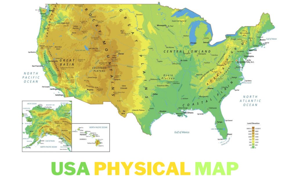
The United States of America is a vast country, covering a total area of approximately 3.8 million square miles. It is the third-largest country in the world by total area and has a diverse range of physical landscapes, from arid deserts to fertile plains, towering mountains, and expansive coastlines. This comprehensive guide delves into the USA Physical Map, exploring its major physical features, the role of natural resources, and the influence of various geographical features on the climate and biodiversity of the country.
Table of Contents
ToggleMajor Physical Features of the USA

Mountain Ranges: The Backbone of America
The Rockies: America’s Majestic Range
The Rocky Mountains stretch over 3,000 miles from British Columbia in Canada down to New Mexico in the southern United States. Characterized by towering peaks, alpine lakes, and diverse wildlife, the Rockies are not just a physical barrier dividing the eastern and western parts of the country but also a stunning attraction for millions of visitors each year.
The Appalachians: The East’s Ancient Hills
Contrasting the Rockies, the Appalachian Mountains extend from Newfoundland in Canada to central Alabama. These mountains are older, shorter, and heavily eroded compared to the Rockies, with the highest peak, Mount Mitchell in North Carolina, reaching 6,684 feet. The Appalachians are renowned for their deciduous forests which display vibrant colors in the fall season.
Rivers and Lakes: The Circulatory System
Mighty Mississippi
Flowing over 2,300 miles from Minnesota to the Gulf of Mexico, the Mississippi River is the second-longest river in North America. This river has been pivotal in the history, culture, and economic development of the United States, serving as a major transportation route for agricultural and industrial materials.
Great Lakes: Freshwater Giants
The Great Lakes—Superior, Michigan, Huron, Erie, and Ontario—form the largest group of freshwater lakes on Earth by total surface area. These lakes hold about 84% of North America’s fresh surface water. The lakes are crucial for commerce, transportation, and recreation, supporting industries from fishing to shipping.
The Great Plains: America’s Breadbasket
Extending from the northern regions of Canada down to Texas, the Great Plains are often referred to as America’s breadbasket due to their extensive agricultural activities. This vast expanse features rolling hills used primarily for farming wheat, corn, and other crops, thanks to the fertile soil and favorable climate.
Deserts of the Southwest
The Mojave: Arid Beauty
Located primarily in southeastern California, the Mojave Desert is home to the famous Death Valley, which is the hottest and driest place in North America. Despite its harsh conditions, the Mojave supports a variety of adapted plant and animal life.
The Sonoran: A Desert Full of Life
The Sonoran Desert covers large parts of Arizona and California and extends into Mexico. It is distinguished by its wet summer ‘monsoon’ season and diverse ecosystems, which include some of the most biologically rich desert areas in the world.
Climate Zones: From Arctic to Tropical
Alaska’s Arctic
Northern Alaska experiences arctic conditions, with permafrost and ice covering much of the landscape year-round. This region’s extreme conditions challenge both wildlife and human inhabitants.
Hawaii’s Tropics
In stark contrast, Hawaii offers tropical climates, with lush vegetation and year-round warmth. The Hawaiian Islands also boast diverse ecosystems, from volcanic landscapes to rainforests.
Coastal Features and Marine Borders
Atlantic Seaboard
From the rocky shores of Maine to the sandy beaches of Florida, the Atlantic coast of the USA offers some of the country’s most iconic scenery. This coastline is especially significant for its historical towns and maritime activities.
Pacific Northwest
The Pacific Northwest is famous for its rugged coastline and temperate rainforests, often shrouded in mist. This area is crucial for its fisheries and timber industry.
How Physical Maps Are Made

The creation of a physical map involves several steps:
- Data Collection: Cartographers collect data from satellite imagery, aerial photography, and ground surveys.
- Design and Editing: Using geographic information systems (GIS), specialists design the map, selecting colors and textures to represent different terrains and elevations accurately.
- Printing and Publishing: Once the map is finalized, it is printed and made available for educational, professional, or recreational use.
Major Rivers and Waterways
Waterways are crucial components of the physical geography of the United States. Major rivers include:
- Mississippi River – America’s longest river, which along with its tributaries like the Missouri and Ohio rivers, drains much of the central USA.
- Colorado River – Known for its dramatic canyons and vital in the arid west for water supply.
- Columbia River – Essential for hydroelectric power to the Pacific Northwest.
- Rio Grande – Acts as a natural border with Mexico and is key in the landscapes of the Southwest.
Key Natural Resources
The USA Physical Map is endowed with a wealth of natural resources that have historically contributed to its economic growth and development:
- Fossil Fuels: The USA is one of the world’s leading producers of oil, natural gas, and coal, with significant reserves located in Texas, North Dakota, and Alaska.
- Minerals: The United States is a major producer of copper, gold, and iron ore, with substantial mining operations in states like Nevada and Minnesota.
- Forests: Vast tracts of forests across the country, particularly in the Pacific Northwest, are not only critical for wood and paper products but also for biodiversity conservation.
- Water Resources – The Great Lakes, the largest group of freshwater lakes in the world by total area, are vital for transport, water supply, and recreation.
Climate Variations
The physical geography of the USA plays a crucial role in the diverse climate patterns observed across the country:
- Pacific Northwest: Known for its wet, rainy weather, which contributes to its lush green landscapes.
- Southwest: Characterized by arid and semi-arid climates, receiving very little rainfall which influences the sparse vegetation.
- Southeast: Exhibits a humid subtropical climate, with hot summers and mild winters, conducive to agriculture.
Biodiversity

The varied climates and geographical features of the USA support a wide range of ecosystems and an abundant diversity of wildlife. Notable examples include:
- Yellowstone National Park: Home to the largest super volcano on the continent and an incredible variety of wildlife, including grizzly bears, wolves, and bison.
- Florida Everglades: A unique ecosystem that houses a vast array of wildlife, including the American crocodile and the Florida panther.
Using USA Physical Map for Education and Travel
USA Physical Map are invaluable in educational settings, helping students visualize where significant historical events occurred and how geography impacts social, political, and economic decisions. Travelers and outdoor enthusiasts also use these USA Physical Map to plan trips and navigate challenging terrains.
Conservation and Environmental Challenges
As of 2024, the U.S. faces several environmental challenges that impact its physical geography, including climate change, deforestation, and water scarcity. Conservation efforts are crucial in preserving the natural beauty and ecological health of the nation. Initiatives aimed at protecting key areas like the Yellowstone National Park, the Smoky Mountains, and numerous other national and state parks are pivotal in these efforts.
Conclusion
The physical map of the USA is more than just a tool for geographical orientation. The USA Physical Map offers more than just a depiction of its natural features; it tells the story of a landscape that has shaped the cultural and economic backbone of the nation. From the majestic peaks of the Rockies to the expansive waters of the Mississippi River, each feature contributes to the complex environmental tapestry that is uniquely American. Understanding this USA Physical Map helps not only in appreciating the natural beauty of the country but also in recognizing the profound ways in which natural features influence the human experience.
This detailed exploration underscores the importance of geographical knowledge in fostering appreciation and stewardship of our natural world, ensuring that its benefits can be enjoyed for generations to come.
FAQs about USA Physical Map
What are the major mountain ranges shown on a physical map of the USA?
The USA physical map prominently features several major mountain ranges, including the Rocky Mountains, which extend from Canada to New Mexico, and the Appalachian Mountains, spanning from Newfoundland in Canada to Alabama. These ranges are key to understanding the geological and ecological diversity of the country.
Which rivers are most prominently featured on the USA physical map?
Major rivers such as the Mississippi, the Missouri, and the Colorado River are essential components of the USA’s physical map. The Mississippi River, for instance, is one of the longest rivers in North America and plays a crucial role in the ecology, economy, and geography of the central USA.
How are the Great Plains represented on a USA physical map?
The Great Plains area is depicted as a vast expanse of flatland that stretches across several states from Texas to North Dakota. Known for its agricultural significance, this area is characterized by its flat terrain and grassy landscape on physical maps.
Can you identify the deserts in the USA on a physical map?
The physical map of the USA shows various deserts, notably the Mojave and the Sonoran Deserts in the Southwest. These regions are identified by their arid terrain, unique vegetation, and the distinct climatic conditions that dominate their landscapes.
What details about Alaska and Hawaii can be observed on a USA physical map?
Alaska is often shown with its rugged mountains and extensive river systems, highlighting its vast wilderness and diverse habitats. Hawaii’s maps emphasize volcanic topography and tropical climate, illustrating its islands’ mountainous terrains and lush vegetation.
How are coastal areas like the Gulf of Mexico and the Great Lakes represented on physical maps of the USA?
Coastal areas and large water bodies such as the Gulf of Mexico and the Great Lakes are detailed with emphasis on their roles in commerce, climate, and local ecosystems. The Great Lakes are usually depicted with clear demarcations of each lake, illustrating their collective status as the largest group of freshwater lakes in the world by surface area.

