
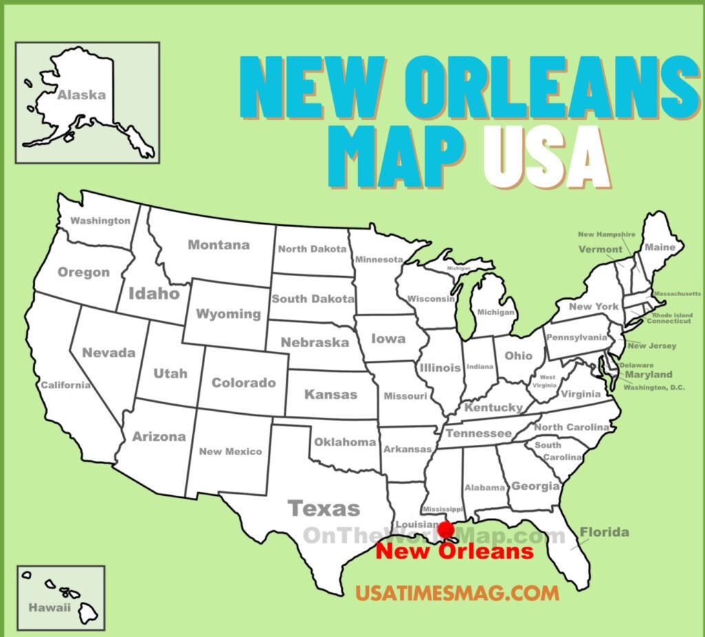
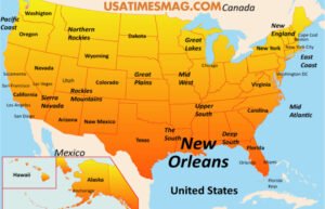
New Orleans, affectionately known as “The Crescent City,” is a vibrant metropolis nestled in the southeastern region of Louisiana, USA. Renowned for its rich cultural tapestry, historical significance, and distinctive geography, New Orleans Map USA offers a unique blend of experiences that captivate both residents and visitors alike.
Geographical Overview
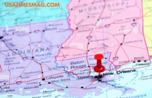
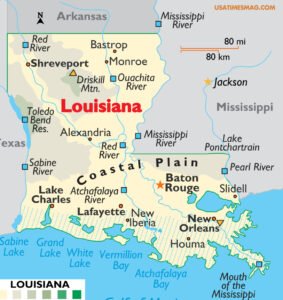
Situated along the Mississippi River, approximately 100 miles upriver from the Gulf of Mexico, New Orleans occupies a strategic and picturesque location. The city’s unique crescent shape, which inspired its nickname, follows the natural curve of the river. This positioning has historically made it a vital hub for trade and transportation.
The city’s topography is notably low-lying, with elevations ranging from 1 to 2 feet below sea level in certain areas to about 20 feet above sea level in others. This characteristic has necessitated the development of extensive levee systems and sophisticated drainage infrastructure to mitigate flooding risks.
Historical Context
Founded in 1718 by French colonists under the leadership of Jean-Baptiste Le Moyne de Bienville, New Orleans has evolved under various sovereignties, including French, Spanish, and American rule. This diverse colonial history has profoundly influenced the city’s architectural styles, cultural practices, and linguistic heritage, resulting in a rich and eclectic cultural milieu.
Cultural Significance
New Orleans is globally celebrated for its vibrant cultural scene, particularly its contributions to music, cuisine, and festivals. As the birthplace of jazz, the city boasts a dynamic music scene that permeates its streets, especially in the historic French Quarter. Culinary traditions in New Orleans are equally renowned, featuring iconic dishes such as gumbo, jambalaya, and beignets, which reflect the city’s Creole and Cajun influences.
The city’s calendar is punctuated by numerous festivals, with Mardi Gras being the most famous. This annual celebration attracts millions of visitors worldwide, drawn by its elaborate parades, vibrant costumes, and exuberant atmosphere.
Neighborhoods and Layout
New Orleans comprises a mosaic of neighborhoods, each with its distinct character and charm. The French Quarter, or Vieux Carré, is the oldest neighborhood, renowned for its well-preserved colonial architecture and lively Bourbon Street. Adjacent to it is the Central Business District (CBD), a bustling area that serves as the city’s commercial heart.
Other notable neighborhoods include the Garden District, famed for its antebellum mansions and tree-lined streets, and Tremé, recognized as one of the oldest African American neighborhoods in the United States, rich in cultural heritage and history.
Navigating the City
Navigating New Orleans Map USA is facilitated by its relatively flat terrain and grid-like street layout, particularly in the older parts of the city. The city’s public transportation system includes buses and the historic streetcars, which offer a scenic and nostalgic mode of travel through various neighborhoods.
For visitors, numerous maps and guides are available to assist in exploring the city’s attractions. Resources such as the New Orleans Official Visitor Guide provide comprehensive information on points of interest, dining, and entertainment options.
Economic Landscape
The economy of New Orleans is diverse, with key sectors including tourism, maritime industries, and energy. The Port of New Orleans is one of the largest and busiest ports in the world, playing a crucial role in international trade. Tourism remains a significant economic driver, with millions of visitors annually contributing to the hospitality and service industries.
Environmental Considerations
Given its low-lying geography and proximity to large bodies of water, New Orleans is particularly susceptible to environmental challenges such as hurricanes and flooding. The city has invested heavily in flood mitigation and coastal restoration projects to enhance resilience against these threats.
Conclusion
New Orleans stands as a testament to the harmonious blending of diverse cultures, histories, and geographies. Its unique location along the Mississippi River, coupled with its rich cultural heritage and vibrant community life, makes it a distinctive and captivating city within the United States. Whether drawn by its musical legacy, culinary delights, or historical landmarks, visitors to New Orleans are sure to find an experience that resonates with the city’s enduring spirit and charm.
FAQs about New Orleans Map USA
Where is New Orleans located in the United States?
New Orleans is situated in the southeastern region of Louisiana, along the Mississippi River, approximately 100 miles upriver from the Gulf of Mexico. It is the largest city in Louisiana and serves as a major port and cultural hub in the southern United States.
What are the main neighborhoods in New Orleans, and where are they located on the map?
New Orleans is composed of several distinct neighborhoods, each offering unique cultural and historical experiences:
- French Quarter (Vieux Carré): The oldest neighborhood, known for its vibrant nightlife and historic architecture, located along the Mississippi River.
- Garden District: Famous for its well-preserved antebellum mansions and lush gardens, situated to the southwest of the French Quarter.
- Central Business District (CBD): The city’s commercial heart, located just across Canal Street from the French Quarter.
- Uptown/Carrollton: Home to universities and Audubon Park, located upriver from the CBD.
- Faubourg Marigny and Bywater: Known for their bohemian vibe and music scene, located downriver from the French Quarter.
Detailed maps highlighting these neighborhoods can be found on the official New Orleans tourism website.
How can I obtain a detailed map of New Orleans for navigation?
Visitors can access comprehensive maps of New Orleans through various resources:
- Online Maps: Interactive maps are available on platforms like Google Maps, providing real-time navigation and points of interest.
- Printable Maps: The New Orleans tourism website offers downloadable PDF maps, including neighborhood layouts and streetcar routes.
- Mobile Applications: Several apps provide offline maps and guides tailored for tourists exploring New Orleans.
What are the major transportation routes and streetcar lines in New Orleans?
New Orleans features a historic streetcar system and several major roadways:
- Streetcar Lines: The city operates four main streetcar lines: St. Charles, Canal Street, Riverfront, and Rampart/St. Claude, each serving different parts of the city.
- Major Highways: Interstate 10 (I-10) runs east-west through the city, connecting to Interstate 610 (I-610) and Interstate 510 (I-510). U.S. Highways 61 and 90 also serve as significant routes.
Where can I find maps highlighting tourist attractions in New Orleans?
Tourist attraction maps are available through:
- Official Tourism Websites: The New Orleans tourism website provides maps showcasing key attractions, dining, and entertainment venues.
- Visitor Centers: Physical maps are available at visitor centers throughout the city, offering insights into popular sites and events.
How has New Orleans’ geography influenced its cultural development?
New Orleans’ location along the Mississippi River and its proximity to the Gulf of Mexico have significantly shaped its cultural evolution:
- Port City Influence: As a major port, New Orleans became a melting pot of cultures, including French, Spanish, African, and Caribbean influences, which are evident in its music, cuisine, and architecture.
- Neighborhood Diversity: The city’s layout, with distinct neighborhoods like the French Quarter and Garden District, reflects its historical development and cultural diversity.
Understanding the city’s geography through detailed maps can enhance appreciation of its rich cultural tapestry.